|
The Valtatie 4 (Vt4) road between Lahti and Heinola in Finland is prone to severe traffic congestion at certain times, and the Tiehallinto (Finnish Road Administration) installed a journey-time information system (JTIS) to measure vehicle transit times along this stretch of road. NCTR has supplied all the instation and outstation software for this system. The information from it is used to give road users estimates of their likely journey times in each direction, using variable message signs (VMSs) beside the road near Lahti and Heinola, a few kilometres before the start of the monitored sections of road.
The system architecture is similar to the PKS system: the journey times of vehicles travelling north and south along the Vt4 are measured by ANPR and displayed to the operators at the Tiehallinto’s Häme Region Traffic Management Centre in Tampere.
The system is monitored through a Web-based user interface which is accessible to authorised users over the Internet. This interface shows information about the individual routes monitored, and shows the text displayed on the VMSs. It also allows the VMSs to be controlled manually if required, and maintains a log of all changes to the VMS displays.
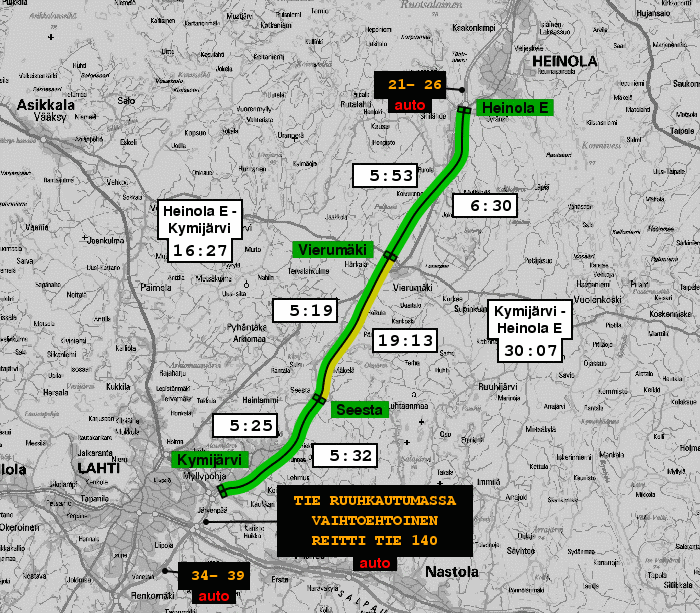
This is an example of the status map presented to the Tiehallinto’s operators. The monitored sections between Kymijärvi and Heinola are colour coded. Green represents free-flowing traffic, and the yellow northbound section between Seesta and Vierumäki indicates traffic moving slowly.
|
|
As well as showing the current journey times in each monitored route, the interface also shows the text currently displayed on the VMSs, which is derived automatically from the journey-time measurements. The VMS near Lahti is showing an increased northbound journey time (34 to 39 minutes) because of the congestion between Seesta and Vierumäki, while the VMS near Heinola shows that southbound traffic is flowing freely (21 to 26 minutes).
The large VMS at Joutjärvi (a little north of the Lahti VMS) displays messages that are selected automatically according to the journey time. In the example shown here, it advises road users that congestion is building up on Vt4, and suggests a road (Tie 140) by which to avoid Vt4.
By clicking on the affected route, the operator can obtain more detailed information about the congestion, including a graph of journey times over the last twelve hours.
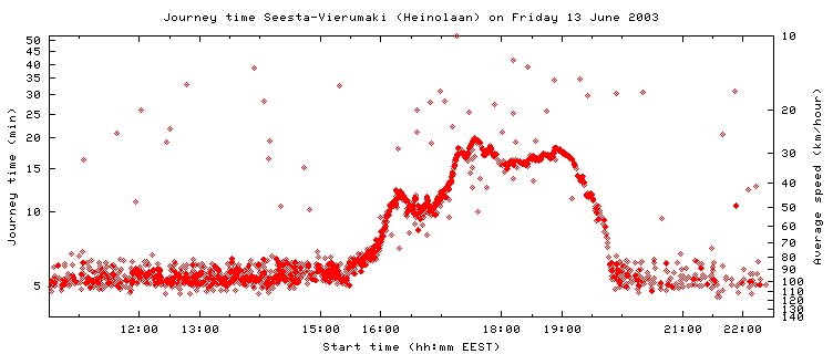
This graph shows clearly that congestion started to build up about 15:30, and then cleared rapidly betweeen 19:30 and 20:00. The snapshot of the operators’ map shown above was taken at about 18:00, which is shortly after vehicles that passed Seesta when congestion was at its worst reached Vierumäki.
The snapshot of the Vt4 operators’ map and journey-time data are shown by courtesy of the Tiehallinto.
$Id: vt4.html,v 1.16 2018/05/19 09:40:55 mkc Exp $